Annual Highlights
Tropical oceanic-atmospheric condition
The La
Niña event came to the end
The La Niña event which began in
August 2007 came to end in May 2008 and lasted for 9 months. Cold-neutral conditions persisted since May.
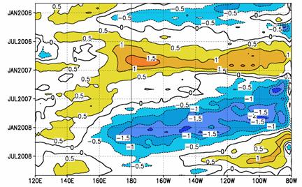
Fig.1 Time -longitude
section of SSTA in the equatorial Pacific (5ºN~5ºS) (Unit:℃ )
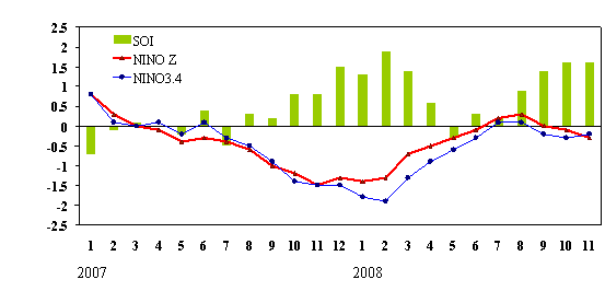
Fig.2 Variations of Niño Z , Niño 3.4 indices (Unit: ℃ ) and SOI
East Asia
summer monsoon
The onset time of the South China Sea
(SCS) was earlier than normal while the end time was later than normal with the
intensity weaker than normal.
The onset
of the South China Sea (SCS) summer monsoon was in the first pentad of May and
earlier than normal. Subsequently, southwesterlies
moved northward to regions south to the Yangtze River.
During mid-June, southwesterlies extended northward
to the Jianghuai area, and warm and humid air was
prevalent south of the Huanghuai area. Southwesterlies moved northward
to North China during mid-July. After
mid-August, warm and moist air swiftly withdrew southward and moved back to the
middle and lower reaches of the Yangtze River, withdrawing further to South China by mid-September and lingered until early
October (Fig.3). The summer monsoon withdrew from the SCS during the second
pentad of October 2008, two pentads later than normal. Overall, the SCS summer
monsoon index during 2008 was -1.37 and weaker than normal. Pentad intensities
of the SCS summer monsoon were stronger than normal during May and the period
from the third pentad of September to the first pentad of October, but
were weaker than normal during most of the period June-August (Fig.4). Over
eastern China, precipitation
totals for summer (June-August) were above 30% more than normal in the Jianghan area, the eastern Huanghuai
area and South China (Fig.5).
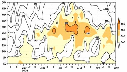
Fig.3 Time-latitude
section of 850hPa θse (110 ºE~120ºE mean) (Unit:K)
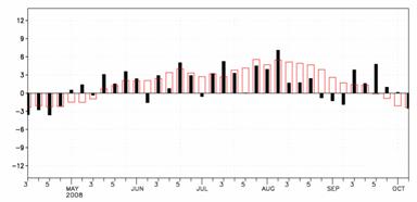
Fig.4 Variation of pentad zonal
wind index over monitoring region, red open bars stand for climatology (Unit:
m/s)
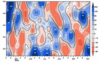
Fig.5 Time-latitude section of pentad precipitation
percentage anomalies over 110 ºE~120ºE (Unit:
%)
Snow Cover
The area of snow cover in China
was larger than normal during 2007/2008 winter.
The areas of snow cover in the Northern
Hemisphere and Eurasia were slightly larger
than normal during winter (Dec.2007- Feb.2008) while all smaller than normal in
spring, summer and autumn. The area of snow cover in China
was nearly 40% larger than normal in winter, with over 50% in the Tibetan
Plateau and over 40% in Northern Xinjiang.
In autumn, snow cover extents China
and
the Tibetan Plateau were obviously larger than normal (Fig.6).
During winter, the number of days with snow cover (NDSC) was over 75
days in northern Europe, most of the regions in Asia north to 50°N and regions in North America north to 40°N. As for China, NDSC
was over 75 days in northern Xinjiang, northeastern
Inner Mongolia and parts of Heilongjiang.
NDSC was observed 10-30 days more than average in western and central North
America and the regions from southeastern Europe to northern China through West Asia.
Meanwhile, NDSC was observed 10-30 days below normal in central Europe, the southern Tibetan Plateau and parts of northeastern China (Fig.7).
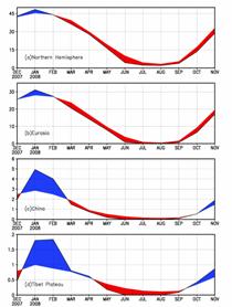
Fig.6 Regional snow cover
anomaly indices (Unit: 106km2 )
(a)
Northern Hemisphere (b) Eurasia (c) China (d) Tibetan Plateau
(dashed line: climatology, solid
line: monthly snow cover area, red: monthly snow cover area is below
climatology, blue: monthly snow cover area is above climatology)
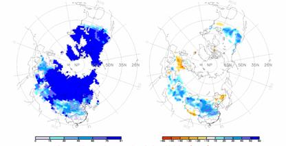
Fig.7
Number of days with snow cover (left) and the
anomalies (right) in the Northern Hemisphere during Dec.2007 to Feb. 2008
(Unit: day)